
White Rock Overlook Trail – Cumberland Gap

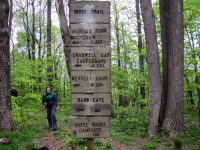
White Rock Overlook Trail – Cumberland Gap Trailhead Location Located at Ewing Trail and Ridge Trail Junction in Cumberland Gap National Park. N36° 39.953′ W83° 26.784′ Park Information Cumberland…


White Rock Overlook Trail – Cumberland Gap Trailhead Location Located at Ewing Trail and Ridge Trail Junction in Cumberland Gap National Park. N36° 39.953′ W83° 26.784′ Park Information Cumberland…

Sand Cave Spur Trail – Cumberland Gap Trailhead Location This trail is accessed off the East Side Ridge Trail, heading North at the Junction N36° 40.070′ W83°…
Ridge Trail East Section – Cumberland Gap Trailhead Location The East side of the Ridge Trail is Located at the end of White Rocks Spur Trail in…

White Rock Spur Trail – Cumberland Gap Trailhead Location Located on Ewing Trail in Cumberland Gap National Park. Park Information Cumberland Gap National Park Trail Features…

Ewing Trail – Cumberland Gap Trailhead Location Located at the Thomas Walker Civic Park in Ewing, VA. Google Park Information Cumberland Gap National Park Trail…
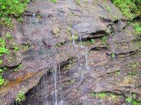
Ada-Hi Falls Trail Trailhead Location Located on Black Rock Mountain Parkway, 3 miles north of Clayton off U.S. Highway 441. Look for brown directional signs…

Edmund’s East-Fork Trail Trailhead Location Located on Black Rock Mountain Parkway, 3 miles north of Clayton off U.S. Highway 441. Look for brown directional…
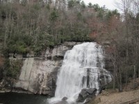
Rainbow Falls Trail – Gorges Trailhead Location Use the Grassy Ridge Access entrance off of Hwy 281 S, in Sapphire. This trail access is…

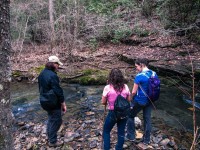
Raymond Fisher Trail Trailhead Location Use the Grassy Ridge Access entrance off of Hwy 281 S, in Sapphire. This trail access is at the…
Savage Gulf State Natural Area – Stonedoor & Laurel Falls Trails South Cumberland State Park – Camping & Hiking Trailhead Location Google Maps Location Park Information…