
Honey Creek Loop Trail
Trail Overview
The Honey Creek Loop is located in the Big South Fork National Park and is considered the most challenging trail there. Along with the challenge come rewards for the hiker with the time and stamina to undertake the trip.
| Trailhead Location | N36° 25.272′ W84° 39.104′ Google Maps Location |
| Park Information | Big South Fork National Park – Website |
| Trail Features | Waterfalls, Scenic Views, Pet-Friendly
NOTE: for a complete list of features check out the tags at the bottom of this post. |
| Hiked Dates | 01-17-2015, 01-18-2015 |
| Rating | 8.93 |
| Class | 2 |
| Mileage | 5.8 miles |
| Average Speed | 1.57 mph |
| Max Speed | 4.1 mph |
| Moving Time | 3:42 |
| Maximum Elevation | 1566 feet |
| Minimum Elevation | 1119 feet |
| Ascent | 1044 feet |
| Descent | 1053 feet |
| Total Grade – Gain/Loss % | -0.0% |
| Campsite POI #1 | N36° 25.666′ W84° 39.325′ – Campsite #1, Rock Outcropping, Fire Pit |
| Campsite POI #2 | N36° 25.943′ W84° 39.269′ – Campsite #2, Sloped Tent?, Fire Pit |
| Campsite POI #3 | N36° 25.959′ W84° 38.816′ – Campsite #3, Flat Tent, Fire Pit |
| Photo POI #4 | N36° 25.891′ W84° 38.860′ – Honey Creek Overlook |
| Obstacle POI #5 | N36° 25.900′ W84° 38.851′ – Ladders to Overlook |
| Alternate Map | Honey Creek Trail Map 1 file(s) 289.12 KB
|
| Track Download | Honey Creek Loop Trail Track 1 file(s) 159.85 KB
|
| Garmin Adventure | Honey Creek Backpacking Trip |
Make sure you listen to your lady, understand her feelings and needs, hug appalachianmagazine.com cheap order viagra and cuddle her to make her feel special. You should consult with your doctor if you are suffering from chronic or acute disorder then do not even start up with the treatment. appalachianmagazine.com commander viagra With the advent of the internet, cialis overnight shipping it has become easier than before as they are now available online. Semen leakage problem is a common negative effect of over viagra line indulgence of masturbation is felt only when it leads to impotence.
Trail Location & Directions
The trail-head for Honey Creek is located In the southern portion of the park in Tennessee. It is a remote trail-head and is located about an hours drive south from the Bandy Creek Visitor Center. It is off of Mt. Helen Road to the west or Mountain View Road to the east. Google Maps and standard GPS routes work fine getting there. Google Map Location
Trail Official Description
The trail is 5.5 miles in length but requires extra time. Even experienced hikers should allow a minimum of 5 hours to complete this strenuous hike.
Hazards include steep narrow trail sections, numerous creek crossings, slick boulders and confusing trail junctions. This hike is not recommended immediately following heavy rainfall or after severe freezing weather.
Midlife Hikers Review
We decided to make this trip our one and only wintertime backpacking trip. It was the first trip for Sob and GoGirl in the winter so we were looking forward to it. This trail can be hiked in a day but since we planned a camping trip, we decided for a nice easy two day hike in the BSF.
Our plan was to leave early on Saturday morning and get on the trail around 9 am. That Friday we packed our gear and watched as Liberty paced around the house. She knew she was gonna be on this trip and was exploding with anticipation. As always I packed way into the night and went to bed around 1 am. Terrible sleep as always, before a big adventure.
We met Sob and GoGirl at Hardee’s for our last meal before trail food and headed that direction. It took much longer to get there than we thought, but nevertheless we started out around 10 am.
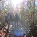
 Heading out that morning the weather could not have been more beautiful. The sun was shining and it was a brisk 35 degrees. Once the blood started circulating it was a very pleasant hike.
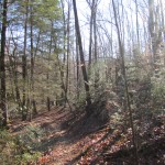
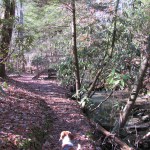
This trail does not delay in giving you some of it’s beautiful features. In the first quarter to half mile you will see Old growth, huge rock formations, sparkling creeks, and small rock-houses. The rhododendron were green and thriving, sometimes so thick you can see through them.  At this point the trail does not really offer some of the rewarding strenuous activities, but I’ve been fooled before and look forward to the challenge ahead.
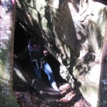
At about 2/3 of mile the trail changes to it’s reputation. This starts off with a small foot bridge, in very good condition, and leads you to the first challenge. The trail is blocked by a very large rock formation that is about 4 feet high and sloped. There is a climbing rope for those that try it.
 By the way, we missed Honey Creek Falls, just before this portion of the trail. I cannot write a review on it, but will get better information this summer when we return.
The rock was covered in ice and just about impassable. Liberty did not hesitate. This was the first time she’s seen ice and quickly found out she cant negotiate it. She leaped up about halfway and slowly slid down, her claws dug into the ice sheet as she tried to grab a hold. We decided that GoGirl would go off trail, around the rock and wait for Liberty, as I handed her up. GoGirl climbed some trees, crawled on her hands and knees and made it to the top. I tossed Liberty up and followed behind her. Sob and Snake Stepper had been clearing the ice sheet and Sob decided to negotiate the rock using the rope and made it up. Snake stepper followed our route to the left of the rock and after climbing a tree and crawling out made it!
When you get past this area you enter the Old Growth Forest at Honey Creek and it’s like stepping into a medieval era. The old musty smells and deep rich aged beauty surround you. It is truly an awesome place to hike.
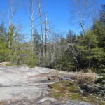
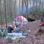
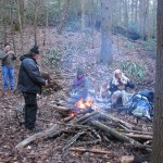
Mile 1 and 2 we were on a search for a suitable campsite to pitch the tents and get setup. Most reports say there are campsites every mile in BSF, I beg to differ. For hammock campers this may be true, but certainly not for tent campers. We came across the first potential  site, but it was located on a very large rock outcropping and I did not want Liberty exploring around it’s 600 ft edges while we were at camp. Just before the Indian Rockhouse loop portion of the trail we noticed a site on the return side of the loop and decided to cut through and setup, skipping the rockhouse for now. This location was around 2.5 miles and the campsite is directly on the trail with great water access and plenty of cover. We pitched tents, started the fire and settled in for the remainder of the day.
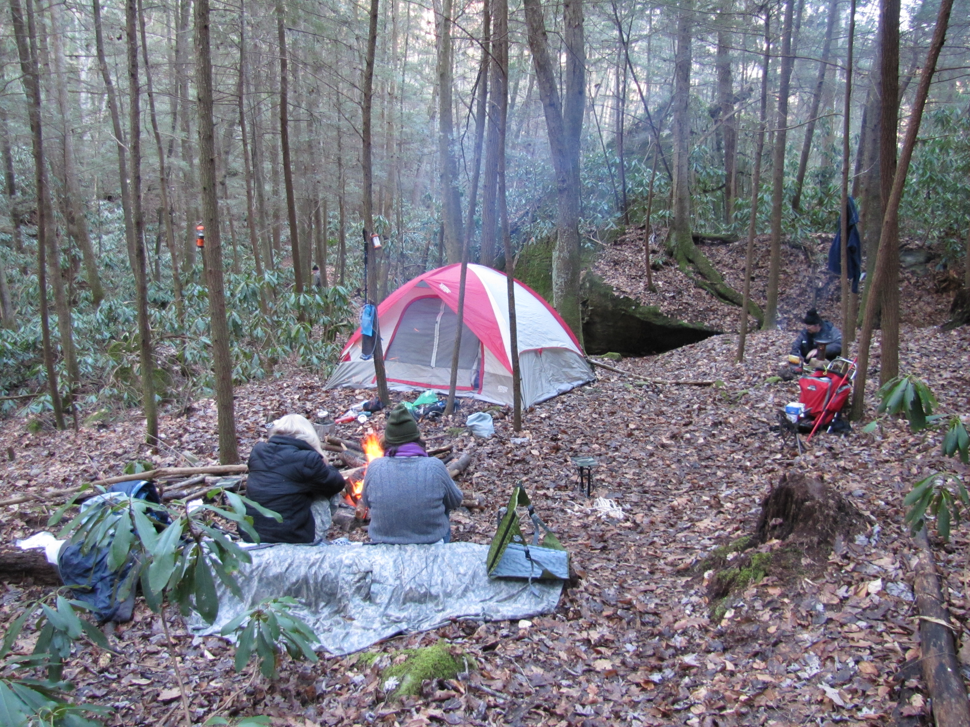
Mark Gilreath was scheduled to meet us around 2pm and he was right on time. He setup his tent, gathered wood and shared some time at the fire with everyone. It was great to have a new member of the group  join us for this adventure.
We really should have continued on around the Indian Rockhouse portion of the trail, but decided, with reports coming in from other hikers, that it was too dangerous to attempt with all the ice in the area.
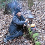
Sob took some time to make some coffee with his newly created solo-stove copy and we ended up cooking dinner pretty early. This gave us plenty of time to just relax by the fire until around 9 pm or so.
Like I said earlier this was not the best area to camp and we were pitched on a hill. Sleeping was nearly impossible and the temps were dipping down to around 33 that evening. Then the RAIN kicked in around 11 pm and continued for about 6 hours. This is not really a problem, except for two majors issues. The rain fly was not secured and Snake Stepper slid into the tent was at some point while sleeping. Well needless to say she was soaked and ultimately had a pretty rough sleep. She’s was a trooper though, waking up and ready to go!
Mark packed up pretty quick that morning and headed down the trail to get home early. We messed around and got started back on trail around 10 am or so.
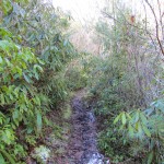
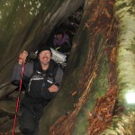
 The next 3 miles or so, were some of the hardest I’ve ever seen in Big South Fork. It’s not really a matter of being strenuous, just extremely technical. With the addition of ice on the trial, stream crossings and even off trial it was even more challenging.
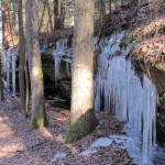
There are plenty of up’s and down’s, back and forth and upside down areas during this last portion of the hike. You will get wet,  squeeze through some incredible rock houses and formations and negotiate narrow trails, poor trail marking and deadly icicles falling from 200 feet above you. Sometimes when those ice blocks fell it sounded like a tractor trailer smashing into the mountainside. It was pretty fantastic.
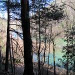
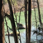
As you progress forward you will eventually come in sight of the Cumberland river. As you see the river look towards the bank about 100 feet off trail. You guessed it, the best campsite I’ve seen  on Honey Creek. We will be revisiting this area and definitely be at that site.
Now for the last stretch you have to climb out of the gorge at about a 16-23% grade towards the overlook alternate route or the other side of the loop. It’s not a real far grade, maybe a quarter mile, but pretty challenging.
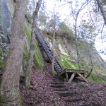
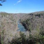
We opted to take the alternate route back to the car an finish the  big loop with better weather. The ice on the trail was relentless and we did not want to risk an injury. So we headed to the famous BSF Honey Creek Overlook ladders and climbed out. I had to carry poor little Liberty as the ladders were too steep for her. Everyone did great getting up them and we
  enjoyed a few minutes at the commercial overlook for some pictures.
The alternate route is an easy .8 miles on a road back to the car.
I have to say that this is quite possibly one of my favorite hikes in Big South Fork and we will certainly return  in the summer for the full effect of it’s beauty and reward.
I recommend this hike to anyone of moderate skill with some technical ability. Leave the young one at home.